A volunteer group promoting quality of life, and the
environment of the Lower Blue River Valley.
The Friends of the Lower Blue River are dedicated to sustaining and protecting the traditional agricultural character, promoting the safety of the residents, livestock and wildlife, and maintaining the environmental integrity of the Lower Blue River Valley through education, collaboration and community involvement.
To sustain and protect the traditional agricultural character, promote the safety of the residents, livestock and wildlife, and maintain the environmental integrity of the Lower Blue River Valley through education, collaboration and community involvement.
Friends of the Lower Blue River is committed to preserving the rich history of the Blue River Valley. Through grant support from the Summit Foundation, we have created this interactive tool that documents and takes you to key points of interest in the Valley. You will see photographs and read about those who came before us. Those who settled this pristine area of Summit and Grand Counties in the 1800’s and the relevance those sites have today. FOLBR invites you to take this journey on our website and discover the treasure, that truly is the Lower Blue River Valley.
Click Here to see History Story Map
A beaver surveying a calm pond
Friends of the Lower Blue River is currently studying the benefits of beaver in the Valley. We are undertaking a stream assessment initiative this summer. Director of Climate Action, Tom Koehler is currently surveying areas of the Lower Blue for potential ecological wetland uplift. He is using a mosaic of mapping tools to indicate where beaver have been, where they might currently exist and where uplifts have the potential to increase species diversity, including beaver in the future. The benefits include, drought resiliency as well as vegetative health for wildlife, stream bank stability and environmental health, such as clean water.

Example of a Beaver Dam Analog
Last month, our Wetlands for Wildlife project, funded and sponsored by Colorado Parks and Wildlife, took real steps forward. We began ground operations along with Ecometrics, uplifting previously modest wetlands, implementing beaver dam analogs as a natural climate solutions tool within our Climate Resilience Initiative. This process allows the stream to expand following historical flows, enhancing biodiversity, mitigating drought impacts and promoting healthy wildlife habitat.
The next phase of this project is already underway creating Geographic Information System (GIS) mapping designs. We are also working to develop field verification teams this autumn to examine the natural intricacies of streams. Next spring, we will continue this work throughout more of the Lower Blue River Valley.


FOLBR Members st Historic Slate Creek Hall
RSVP for Free Tickets on the Eventbrtite Link: https://www.eventbrite.com/e/2024-friends-of-the-lower-blue-river-annual-gathering-tickets-934146345867?aff=oddtdtcreator
The Friends of the Lower Blue River
Annual Gathering
Sunday, August 4, 2024
Historic Slate Creek Hall
11:00am to 2:00pm
Celebrating the Lower Blue River Valley Community
Hear the history and stories from multi-generational ranches
Adam Poe-Pebble Creek Ranch
Peter Roseberry-Brush Creek Ranch
We'll update you on the BLM/Blue Valley Ranch Land Swap
Admission is free
Buffet Lunch from Brother's BBQ
Music from Randall McKinnon
Come meet your neighbors and celebrate the
Lower Blue River Valley

Sam Kirk Aboard Charlie
Sam Kirk currently serves as President of the Friends of the Lower Blue River Board of Directors. He will become Immediate Past President in August.
He is a long-time resident of the Lower Blue River Valley. Sam resides at Pebble Creek Ranch where he currently serves as ranch liaison as well as manager of the Pebble Creek Horse Association. He's been a member of FOLBR since its inception. This is the second time Sam has taken on the role of President of the Board.

Four area environmental non-profits come together to present a series of programs over the next four months. The first event is June 19th hosted by HC3 at Mi Casa in Breckenridge. All the events are from 5:30 to 7:00pm. Come join the conversation about our environment and our most important resource. Mark your calendars for each event, especially FOLBR's on September 18th at the Thisrsty Pika in Silverthorne.

The carbon offset market has been damage recently, bringing some real doubt to its legitimacy. First, it’s important to understand the intent of these offsets is to better gauge the legitimacy of the market moving forward.
Voluntary carbon markets exist for companies and other buyers to purchase carbon credits. The credits offset their emissions and can be used to attempt to achieve “net zero” targets. A lot of these are forest based. Some believe the carbon capturing attributes of the forest or other landscapes can offset a company’s emissions.
With pressure from political, environmental and shareholder activists, companies found themselves bolstering sustainability efforts and even touting ambitious net-zero goals. Reducing emissions can be difficult both on an operational level and throughout a company’s supply chain.
Offset markets were thought to be a large part of the answer, to achieve the somewhat misleading net-zero pledge. Companies began purchasing them and for a while, the market was booming as the price of carbon credits increased.

The first humans in the Lower Blue River Valley were the Ute Indians. They were residents for over 10,000 years, all the while endeavoring to live in harmony with nature and with each other.
In the 1880’s, settlers and miners encroached on the Ute territories, including the Lower Blue River Valley. This led to conflicts between the Utes and the intruders on their ancestral homeland. Their long-standing tenure finally came to an end in 1881. The Ute Indians were forced, by decree, onto smaller reservations in Colorado and larger ones in Utah. The move was enforced by a federal government pressured by agricultural, mining and commercial interests.
Although the Federal Homestead Act was passed in May of 1862, the first homesteads for the valley were not granted until 1882. Realizing the potential for ranching and farming, settlers from Illinois, Kansas and Arkansas, sought the 160 acres provided by the Act. Miners also wanted out of the mines seeking the land of opportunity in the Lower Blue.

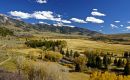
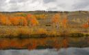
The Blue River below Green Mountain Reservoir is truly a special place. The nearest town on the map is Heeney. The proximity to Silverthorne makes it a worthwhile place to explore without having to travel far to have some aquatic fun. While the majority of the Lower Blue River is surrounded by private property, the 3.8-mile canyon section below the Green Mountain Reservoir dam to Spring Creek Road is a wonderful place for the public to access. It is challenging to navigate from the parking area below the dam due to the steep hill, especially during winter. Most canyon enthusiasts make the effort to either look around at the beauty or go fishing.
When the water flows increase to 500 cfs and above, that is when people like to float down the river to either the Spring Creek Road access or continue to the confluence of the Colorado River near the Gore Canyon Access area. The length of the float from Spring Creek Road to the confluence of the Colorado River is 10 river miles. Remember, the Spring Creek Road Access is a take-out only section, specifically for kayakers. It is not a take-out for rafts and is not a put-in for boats of any kind. Rafters who launch below the dam are committed to the 13.8 river mile float to the confluence of the Colorado.